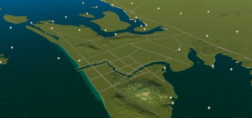
Canberra Australia Map v0.0.1
1901, the colonies of Australia unite and agree to form the Commonwealth of Australia.
Following a long dispute over whether Sydney or Melbourne should be the national capital, a compromise was reached: the new capital would be built in New South Wales, so long as it was at least 100 miiles from Sydney. The capital city was founded and formally named as Canberra in 1913.
The area chosen for the capital had been inhabited by Aboriginal Australians for up to 21,000 years, by groups including the Ngunnawal and Ngambri. A plan by the American architects Walter Burley Griffin and Marion Mahony Griffin was selected after an international design contest, and construction commenced in 1913.
Unusual among Australian cities, it is an entirely planned city. The Griffins’ plan featured geometric motifs and was centred on axes aligned with significant topographical landmarks such as Black Mountain, Mount Ainslie, Capital Hill and City Hill. Canberra’s mountainous location makes it the only mainland Australian city where snow-capped mountains can be seen in winter, although snow in the city itself is uncommon.
Installation:
– Extract the .cok and .cok.cid files into your folder “AppData/LocalLow/Colossal Order/Cities Skylines II/Maps”
– If there is no “maps” folder yet in this folder, create a Maps folder.
Map Information: THEME: North American CLIMATE: 11 – 27 C LATITUDE: Southern Hemisphere BUILDABLE AREA: 80% OUTSIDE CONNECTIONS: Road. Rail. Air. NATURAL RESOURCES: Forestry, fertile land, Oil, and Ore available.


