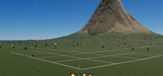
Star Carr Map v0.0.1
In an area of modern-England now known as the Vale of Pickering, once sat a great lake. Although that lake is long gone, the memory of it remains. This map is based on the area’s ancient shoreline and contains the lake that no longer exists.
Star Carr is a stone age archaeological site and is generally regarded as the most important and informative Mesolithic site in Great Britain. The site was occupied during the early Mesolithic period. Although the ice age had ended and temperatures were close to modern averages, sea levels had not yet risen sufficiently to separate Britain from continental Europe. Highlights among the finds at Star Carr include Britain’s oldest structure, 21 red deer stag skull-caps that may have been headdresses and nearly 200 projectile points made of red deer antler. These organic materials were preserved due to having been buried in waterlogged peat. Usually all that remains on Mesolithic sites are stone tools.
Radiocarbon dating of the site indicates occupation first began here between 9335 and 9275 BC, lasting for a period of around 800 years until 8525–8440 BC.
Installation:
– Extract the .cok and .cok.cid files into your folder “AppData/LocalLow/Colossal Order/Cities Skylines II/Maps”
– If there is no “maps” folder yet in this folder, create a Maps folder.
Map Information: THEME: European CLIMATE: -5 – 33 C LATITUDE: Northern Hemisphere BUILDABLE AREA: 61% OUTSIDE CONNECTIONS: All Connections available. Road. Rail. Sea. Air. Power. NATURAL RESOURCES: Fertile, Oil, and Ore cover most of the land.


